In an age long before GPS and satellite imagery, medieval maps served as humanity’s imaginative landscapes: A means of navigating not just physical space, but moral and spiritual worlds as well. Unlike modern maps, these works of art and thought weren’t meant to be geographically precise. Instead, they were a synthesis of faith, philosophy, and artistic interpretation. From the simple T-O maps to the iconic mappae mundi, medieval maps captivate us today with their beauty, their peculiar inaccuracies, and their rich symbolism. But what exactly makes these maps so intriguing, and why are they central to our project?
Medieval maps are more than historical artifacts; they are a bridge between disciplines, uniting theology, cartography, and art history in ways that provoke critical inquiry. At Maps & Monsters, we explore these maps not only as tools for generating knowledge, but also for challenging our assumptions about how humanity has constructed the world across centuries. They remind us that art, far from being a passive reflection of reality, is a powerful framework for shaping perceptions, cultural norms, and even political ideologies.
Art history as a discipline benefits from this perspective by pushing boundaries. Instead of treating maps as mere objects of study, our essays interrogate their roles as active participants in medieval life. They posed questions about the known and the unknown, the sacred and the profane, and the self vs the other. These visual narratives don’t just depict the medieval worldview. They construct it.
We aim to position maps within the broader Anthropocene discourse, exploring humanity’s role in shaping not just the earth but its intellectual and spiritual landscapes. Medieval maps, filled with monstrous races and allegorical geography, show us how medieval Europeans grappled with the limits of knowledge, fear of the unknown, and aspirations for universal order. This framing invites us to reflect on our contemporary moment. Just as medieval maps revealed the anxieties and hopes of their creators, they hold a mirror to today’s debates about globalisation, environmental responsibility, and cultural understanding.
One of the central tenets of Maps & Monsters is that understanding medieval maps demands innovative forms of storytelling. To think differently about the past, we must write differently, experimenting with formats that engage readers beyond linear analysis. Medieval maps are particularly suited to such an approach because they themselves defy strict categorisation. Part cartography, part theology, and part narrative, these maps demand that we embrace interdisciplinary methods. They aren’t mere illustrations but dynamic objects that challenge our perceptions of space, culture, and humanity’s place within the cosmos. Through creative storytelling, we aim to reconnect audiences with the wonder and complexity of these medieval artifacts, offering a model for rethinking how art history is communicated.
Monsters at the Margins of Medieval Maps
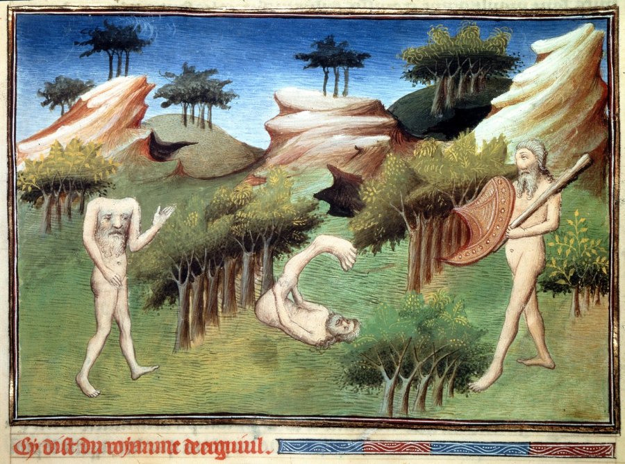
One of the most visually arresting features of medieval maps is their depiction of monsters. Cynocephali (dog-headed men), Sciapods (one-legged people who shaded themselves with their giant feet), and Blemmyes (headless beings with faces on their torsos) populate the edges of these maps. These monstrous races were placed at the peripheries of maps to mark the boundaries of the known world, symbolising the point where Christian civilisation ended, and the alien, dangerous unknown began. This geographic placement was not accidental: the monstrous was closely associated with remote lands, often described as climatically extreme and inhospitable.[1]
Travel literature, such as Marco Polo’s accounts or Sir John Mandeville’s fantastical journeys, further reinforced these ideas. Polo’s Description of the World offered European audiences vivid, albeit exaggerated, glimpses of distant lands populated by extraordinary creatures and customs. Mandeville’s Travels went even further, blending fact with fiction to describe monstrous races and marvels at the edges of the known world. These narratives, while far from accurate, shaped how medieval Europeans imagined the distant and unknown, influencing the monstrous imagery on maps such as the Hereford Mappa Mundi.[2] Such visualisations relied on inherited ideas from classical sources, like Pliny’s Natural History, and on the contemporary travel compilations, which depicted extraordinary beings alongside descriptions of real geographical features.[3]
However, these monstrous races were not purely symbols of fear. As Evelyn Edson argues, they also represented the diversity of God’s creation, serving as reminders of the vastness of the divine plan.[4] For instance, the inclusion of monstrous races on maps like the Ebstorf and Hereford Mappa Mundi was as much about reinforcing Christian cosmology as it was about exploring the limits of the known world. The Ebstorf Map, for example, integrates depictions of races into a larger theological framework, showing Christ’s hands stretching toward the map’s margins, encompassing even the most alien of beings.
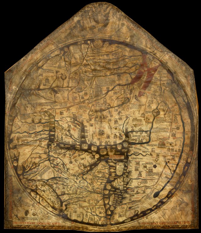
Hereford Mappa Mundi, c. 1300. Hereford Cathedral.
Medieval maps, therefore, functioned as much more than geographical tools. They were cosmological diagrams that blended theology, art, and social commentary. The inclusion of monstrous races illustrated the boundaries of medieval knowledge, simultaneously expanding and containing the imagination of the world. By externalising fears and fantasies onto these figures, mapmakers created a visual language of inclusion and exclusion that upheld cultural norms and power structures. The monsters that haunt their margins are more than fanciful decorations; they are projections of cultural anxieties and aspirations. They delineate the boundaries of civilisation, marking where the familiar ends and the alien begins. By externalising fears onto these monstrous figures, mapmakers reinforced cultural and religious hierarchies, distinguishing the civilised Christian world from the ‘barbaric’ unknown.
In doing so, they remind us that the act of mapping is never neutral. Whether medieval or modern, maps shape how we see the world and, by extension, how we act within it. For this reason, studying medieval maps isn’t just an exercise in historical curiosity. It is a way to critically examine the narratives we construct about the world and ourselves. In the words of Jeffrey Jerome Cohen, ‘The monster is continually linked to forbidden practices, in order to normalize and to enforce. The monster also attracts’.[5] By studying these medieval maps and their monstrous inhabitants, we can better understand the forces that shape our perceptions of the world: past, present, and future.
Further reading
Bartlett, Robert. «Illustrating Ethnicity in the Middle Ages.» In The Origins of Racism in the West, edited by Miriam Eliav-Feldon, Benjamin Isaac, and Joseph Ziegler, 132–156. Cambridge: Cambridge University Press, 2009.
Camille, Michael. Image of the Edge. The Margins of Medieval Art. London: Reaktion Books, 1992.
Campbell, Mary. The Witness and the Other World: Exotic European Travel Writing, 400–1600. New York: Cornell University Press, 1988.
Cohen, Jeffrey Jerome. ‘Monster Culture.’ In Monster Theory, edited by Jeffrey Jerome Cohen, 3–25. Minneapolis: University of Minnesota Press, 1996.
Edson, Evelyn. Mapping Time and Space: How Medieval Mapmakers Viewed Their World. London: The British Library, 1997.
Heng, Geraldine. The Invention of Race in the European Middle Ages. Cambridge: Cambridge University Press, 2018.
Mittman, Asa Simon. «Are the ‘Monstrous Races’ Races?.» In postmedieval: A Journal of Medieval Cultural Studies 6, no. 1 (2015): 36–51.
Mittman, Asa Simon. Maps and Monsters in Medieval England. New York: Routledge, 2006.
[1] Michael Camille, Image of the Edge. The Margins of Medieval Art (London: Reaktion Books, 1992), 14.
[2] Geraldine Heng, The invention of race in the European Middle Ages (Cambridge: University of Cambridge Press, 2018), 349-350.
[3] Robert Bartlett, ‘llustrating Ethnicity in the Middle Ages,’ in The Origins of Racism in the West, ed. Miriam Eliav-Feldon, Benjamin Isaac, and Joseph Ziegler (Cambridge: Cambridge University Press, 2009), 132–156, 132-133.
[4] Evelyn Edson, Mapping Time and Space: How Medieval Mapmakers Viewed Their World (London: The British Library, 1997), 22-23.
[5] Jeffrey Jerome Cohen, ‘Monster Culture,’ in Monster Theory, ed. Jeffrey Jerome Cohen (Minneapolis: University of Minnesota Press, 1996), 3–25, 4.
